Use the links below to move around our Railway pages
Stations on the Coastal Line
North Walsham | Mundesley on Sea | Trimingham | Sidestrand Halt | Overstrand | Cromer Links Halt | Cromer High | Cromer Beach | Roughton Road Halt
Interesting Features on the Coastal Line
The Coastal Line
Our “What’s this?” screens
A Running in Board is a large sign showing the name of the railway station on the platform. The signs are intended to inform passengers of their location as their train pulls into the station, possibly while still moving at speed.
In normal circumstances a two-platform station has one running in board on each platform, situated near the end of the platform that the trains serving the platform will run in – hence ‘running in board’.
Did you know…
During the Second World War, running in boards in the United Kingdom were removed or obscured to prevent enemy spies or paratroopers from easily discovering their location
The halt is a lovely old fashioned term that conjures up images of rural quaintness that’s been lost over time, but that will live on in memories due to the unique part they played in the life of the communities they served.
Back in the day, a passenger station was defined as such by the fact of being able to issue tickets, and a goods station by virtue of being able to receive and handover merchandise/goods, etc to the public.
The halt, or station halt, was a station that had minimal facilities and where trains would usually only stop if the guard advised the driver of anyone travelling there or if there were passengers waiting on the (usually) single platform. They were usually unmanned which meant that tickets had to be bought on the train.
Those old enough may remember stations being “demoted to a halt” during the railways modernisation period, including our very own Paston & Knapton station in the 1950s.
Fare Evasion…
It’s worth remembering that a passenger on a train without a ticket could legitimately be there if they’d started their journey at a halt. This would not be the case where the passenger had boarded at a station.
Contact Us
If you have any photos or memories about our railway that you’d like to share, or if you’d like to make a comment or correction or provide us with further information that we can include on our Railway pages, please click the button below to open our on-line Contact Form.
Selecting Railway from the drop down Subject list ensures that your comment will be passed direct to us and we will normally respond with 24hrs.
When we researched the story of how the railway came about in the first place, we found ourselves constantly confused for the first few days. Every time we thought we’d got our head around it, we’d find another snippet of information that required us to re-think what we thought we knew. The story involves lots of different railway companies all doing bits, coming and going, some sharing, some merging, then grouping…
So, here’s what we think happened…
First, a railway line was constructed that ran from Norwich – North Walsham – Cromer High by the Great Eastern Railway…
Once upon a time…
It all began with the East Norfolk Railway’s (ENR) plan for their Norwich-North Walsham-Cromer line which was first deposited in 1859. It began work in 1865 but delays and constant funding issues meant that the line did not reach North Walsham, via Wroxham, until 20th October 1874. But it was built well and this section of track is still used today, forming part of the Bittern Line.
But the single track line (shown as a solid brown line on the map) was incomplete, with neither the crossing keeper’s cottages nor the goods sheds being finished, which was almost certainly due to a lack of early cash flow. The same liquidity issues may have caused the building of the single track extension to Cromer to be delayed and be the reason that the Great Eastern Railway (GER) operated the line from when it opened, which meant that the fares on the line, along with goods rates, were harmonised with – and set by – the GER.
So the railway finally arrived in Cromer, just in time for the tourist season with the opening of Cromer High railway station in the summer of 1877. Initially no-one seemed to mind that it was on the edge of town and up a steep incline, but the writing was on the wall and had been for some time. Although up to that point the ENR had been nominally independent and had continued to struggle on for another four years, it was finally incorporated into the GER in 1882.
Ten years later a second station, Cromer Beach, was opened by the Midland and Great Northern Joint Railway (M&GNJR) in the heart of the town bringing visitors from the East Midlands. The Cromer tunnel (the only tunnel to be built in Norfolk) was built to link the Cromer Beach station with the Mundesley line to the east.
What was the Great Eastern Railway?
The Great Eastern Railway (GER) was a pre-grouping British railway company, whose main line linked London Liverpool Street to Norwich and which had other lines throughout East Anglia.
Formed in 1862 after the amalgamation of the Eastern Counties Railway and several other smaller railway companies, the GER served Cambridge, Chelmsford, Colchester, Great Yarmouth, Ipswich, King’s Lynn, Lowestoft, Norwich, Southend-on-Sea (which was opened by the GER in 1889), and East Anglian seaside resorts such as Hunstanton (whose prosperity was largely as a result of the GER‘s line being built) and Cromer.
It also served an East London suburban area that included Enfield, Chingford, Loughton and Ilford which went on to become the busiest steam-hauled commuter system in the world during the early 20th century.
The Great Eastern Railway was grouped into the London and North Eastern Railway (LNER) in 1923.

A 1907 Railway Clearing House map showing the North Walsham – Cromer section of the Norfolk and Suffolk Joint Railway (in dotted brown/yellow) and connecting lines
Second, someone decided to build another railway line that also ran from North Walsham – Cromer, only this time it would follow a scenic route via the coast to cash in on the holidaymakers that they were sure would come.
A bit like a Kenin Costner film but without the happy ending…
The Railways Act 1921, also known as the Grouping Act, was an Act of Parliament enacted by the British government and intended to;
- stem the losses being made by many of the country’s 120 railway companies
- move the railways away from internal competition
- retain some of the benefits which the country had derived from a government-controlled railway during and after the Great War of 1914–1918
The provisions of the Act took effect from the start of 1923.
You can read more here
The Railway Clearing House (RCH) was an organisation set up to manage the allocation of revenue collected by pre-grouping railway companies for the conveyance of passengers and goods over the lines (or using the rolling stock) of other companies. It went on to become the major regulatory body overseeing the day-to-day running of railways in Great Britain and setting common standards for railway companies, which ensured their safety and interoperability. The RCH also produced fare structures governing many aspects of rail transport at a national level and set limits on price increases for passenger travel.
You can read more here
Camping Coaches were holiday accommodation offered by many railway companies in the United Kingdom from the 1930s. The coaches were old passenger vehicles no longer suitable for use in trains, which were converted to provide sleeping and living space at static locations.
Norfolk and Suffolk Joint Railway
The original intention of building another railway between North Walsham and Cromer was to take advantage of tourism and develop holiday resorts at Mundesley and Overstrand (shown as a brown and yellow line on the map). Unfortunately opposition from the landowner meant that initially the line was only authorised to go as far as Mundesley.
So they set to work on a section of railway track from North Walsham to Mundesley via one other station, Paston & Knapton.
At the same time, fresh from an expensive spat over traffic in the Midlands and anxious to avoid further wasteful competition, the two railway companies involved, the Midland and Great Northern Joint Railway (M&GNJR) and the Great Eastern Railway (GER), joined forces to form the Norfolk and Suffolk Joint Railways Committee (NSJR). This rail company managed to gain authorisation for the intended extension to Cromer in 1898 at around the same time as the line to Mundesley was finally opened on 20th June 1898, though it wasn’t officially opened to the public until 1st July 1898.

A J15 class 0-6-0 loco which would have been seen using the line through Knapton until the 1956, when they were replaced by Diesel Multiple Units (DMUs)
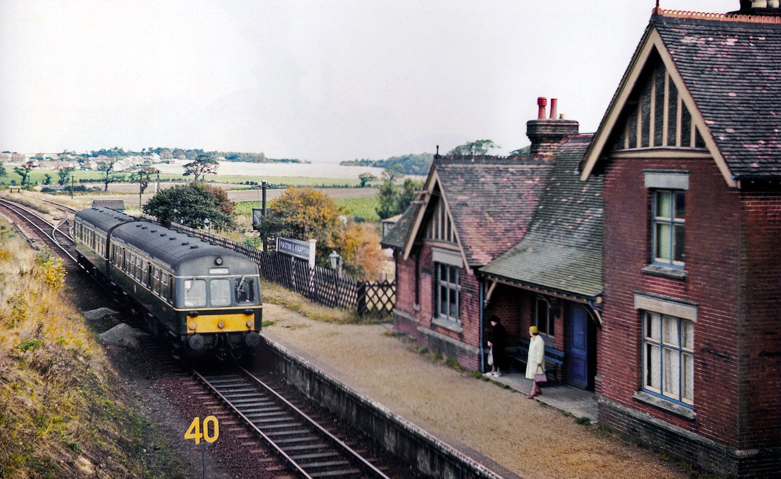
A DMU at Knapton station | late 1950s
This meant that they could now start on the extension from Mundesley to Cromer (Roughton Road Junction) with stations at Trimingham and Overstrand. It opened on 3rd August 1906, following an Act on the 7th August 1896 which authorised the building of the line from Mundesley to Cromer which passed south of Cromer and curved back to approach the town from the west, connecting to the M&GNJR at Runton Junction, and so allowing access to the far more popular Cromer Beach station.
The NSJR also ran the line from Yarmouth – Lowestoft, which connected to the M&GNJR line at Great Yarmouth, which in turn ran to North Walsham
Camping Coaches
Camping Coaches were holiday accommodation offered by many railway companies in the United Kingdom from the 1930s. The coaches were old passenger carriages that were no longer deemed to be suitable for passenger service which were converted to provide sleeping and living space and positioned at picturesque places around their network.
The charges for the use of these coaches were designed to encourage groups of people to travel by train to the stations where they were situated; they were also encouraged to make use of the railway to travel around the area during their holiday.

History
Camping coaches were first introduced by the LNER in 1933, when they positioned ten coaches in picturesque places around their network.
The following year the LMSR, with what it originally called “caravans”, and the GWR which called them “camp coaches” followed suit and in 1935 they were introduced on the Southern Railway.
At the outset of the 1935 season there were 215 coaches at 162 sites through Great Britain. They proved popular and their numbers were steadily increased so that in 1939 there were 439 coaches in use, more than half of which were situated on the LMSR.
During World War II the coaches were generally unavailable to the public after 1940 as they were used by various authorities as emergency accommodation and by the end of the war most of the coaches needed refurbishment before they could be put back into public use. Only the Southern Railway made this effort.
After the railways were nationalised a second generation of camping coaches were introduced from 1952 by British Railways. These vehicles were generally more up-to-date, spacious and better equipped and in the early 1960s the stock was further enhanced by the conversion of some redundant Pullman coaches, resulting in the service peaking at 223 vehicles in 1962.


a Pullman railway coach in a state of
ruin in Cornwall in 2003
&
a Pullman rescued in the late 1990s
and subsequently fully restored
The Beeching Cuts closed many of the smaller lines where the Camping Coaches were located. This effectively signalled the end of the service and the coaches were either sold off or scrapped. The last coaches available for public use were withdrawn at the end of the 1971 season.
Coaches at Mundesley & Overstrand
Mundesley was host to a LNER camping coach from 1938 – 1939. Two 54ft (16m) long former GER coaches were positioned here by Eastern Region of British Railways in 1952, then four coaches from 1953 -1958, then ten more GER coaches for 1959 reducing to six coaches from 1960 – 1964, 3 coaches remained for the 1965 season despite the station having closed.
Eastern Region also positioned two coaches in Overstrand in 1952 for the season.
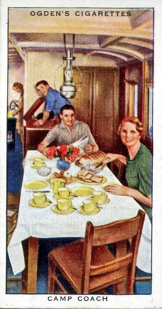
One of a series of cigarette cards issued
by Ogden’s Tobacco in the 1930s, showing
a rather jolly, staged impression of the
interior of a GWR Camp Coach
Click here if you’d like to know more about Camping Coaches.
Cromer Tunnel
Cromer Tunnel
previous station | next station
Cromer Links Halt | Cromer Beach


The railway had come to Cromer in 1877 with the opening of Cromer (High) railway station by the GER and it’s Norwich-Cromer line. Ten years later a second station, Cromer (Beach), was opened by the Midland and Great Northern Joint Railway (M&GNJR) bringing visitors from the East Midlands right into the heart of the town, making it extremely popular.
This second station, now known simply as Cromer station, is the one that remains in use today and serves the Bittern Line. Last year over 214,000 passengers passed through Cromer station.
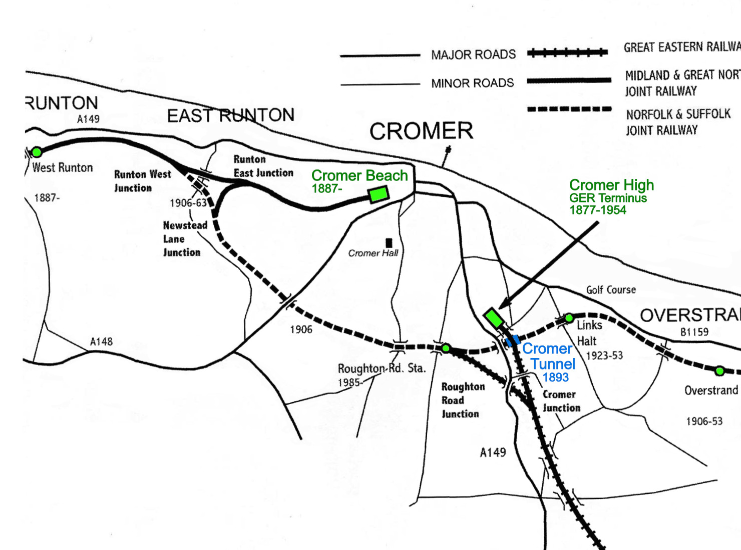
Diagram showing the NSJR line passing
under the GER line through the tunnel
The Cromer Tunnel was built in 1893 by the NSJR to link Cromer Beach Station with their Mundesley coastal route line (our line) by taking it under the GER’s Cromer High – Norwich line so that the trains on our coastal line could run into Cromer Beach station, in the centre of town.


The only Standard Gauge Tunnel in Norfolk
it was just 61yds (56m) long
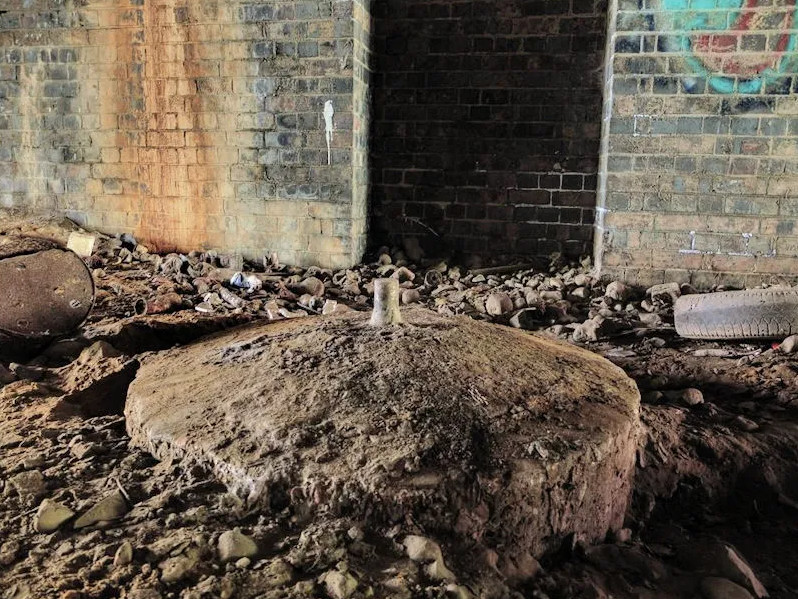
Did you know…
During the Second World War, the local Home Guard set up a spigot mortar base (as above) about 70ft (21m) inside the tunnel, should the Germans have ever invaded
Clearly visible in some photographs of the tunnel are posts along the left-hand side which once carried signal cabling, while set into the wall on the right, were two portals (safety shelters) for anyone working in the tunnel seeking to protect themselves from approaching trains.
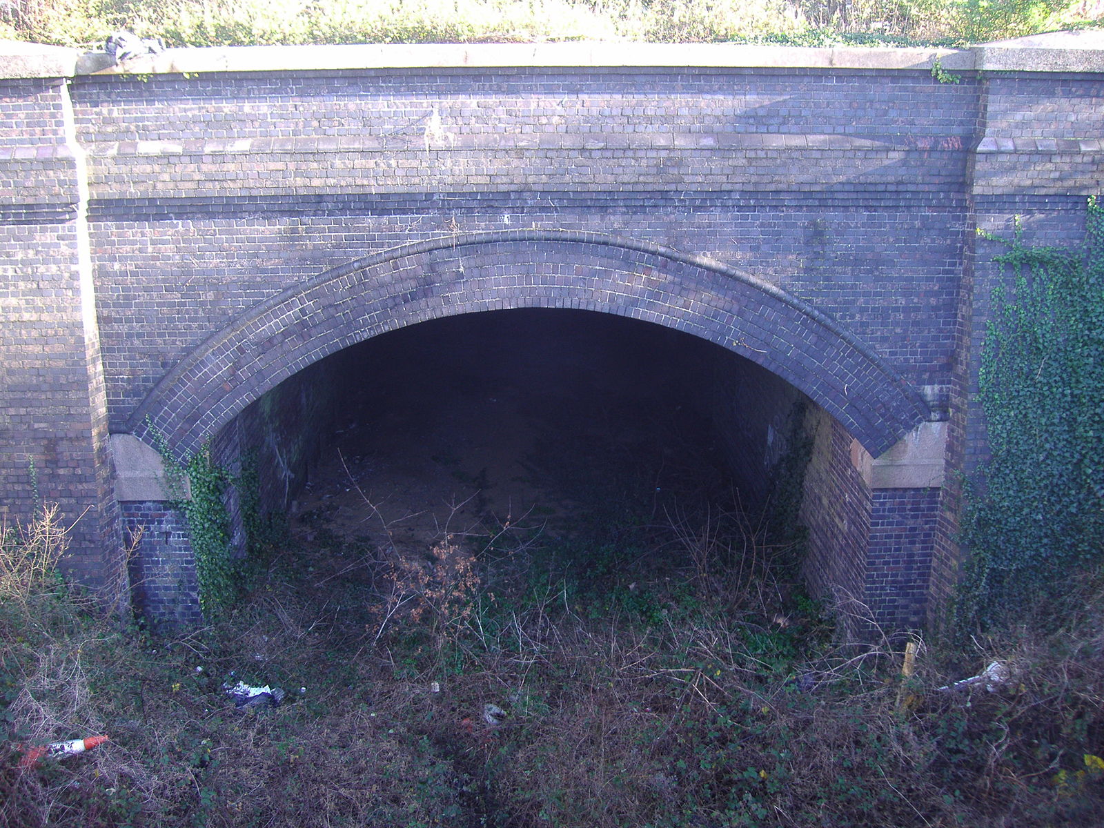
Today
Although disused since services ceased in 1953, the tunnel remains intact and is still Norfolk’s only remaining former ‘standard gauge’ railway tunnel.
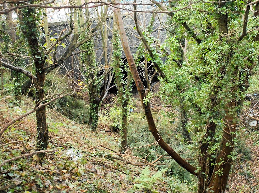
It can be seen on the Overstrand side of the main A140 road at the Northrepps but although both portals of the tunnel remain open, access is difficult due to undergrowth and a housing development on the former trackbed.
The end of the line
For most of its life, the line between North Walsham – Mundesley – Cromer Beach was served by around half a dozen trains each way per day. But with no direct service to Norwich (the nearest city) and with the number of holidaymakers dwindling, the line between Mundesley – Roughton Road Junction was used less and less until finally, on 7th April 1953, British Rail closed it as part of a package of early rationalisation measures after nationalisation. Around a hundred passengers boarded the last train on that day and demand exceeded supply for the souvenir tickets which were issued, causing some to believe that if the level of support had mirrored actual usage of the line it may not have had to close.
Trains continued to run on the line between North Walsham – Paston & Knapton – Mundesley until it too was closed on 28th December 1964 as part of the Beecham Cuts.
The coastal line, although highly picturesque, carried little traffic and its closure made sound economic sense to British Railways.
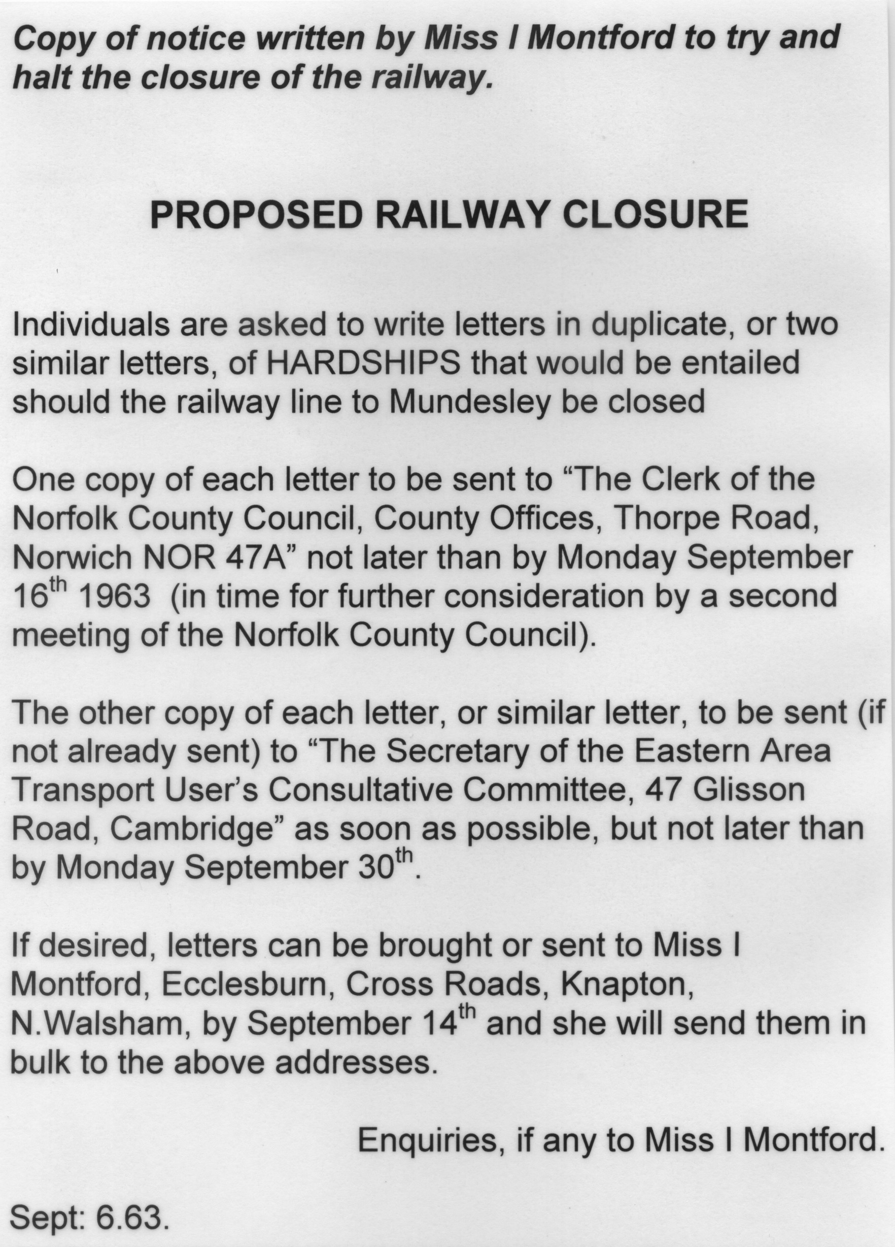
Protest by Miss I Montford | Sep 1963
The Beeching Cuts
During the 1960s British Railways began introducing a programme of cuts to reduce about a third of rail track in Britain. Known as “The Beeching Cuts” or “The Beeching Axe”, it was a plan to increase the efficiency of the nationalised railway system which was outlined in two reports written by Richard Beeching and published by the British Rail Board.
- The Reshaping of British Railways (1963)
This first report identified 2,363 stations (55% of all stations) and 5,000 miles (8,000 km) of railway line (30% of route miles) for closure, and 67,700 British Rail positions, with an objective of stemming the large losses being incurred during a period of increasing competition from road transport and reducing the rail subsidies necessary to keep the network running - The Development of the Major Railway Trunk Routes (1965)
This second report identified a small number of major routes for significant investment. The 1963 report also recommended some less well-publicised changes, including a switch to containerisation for rail freight
Protests were made to try to prevent line closures, such as the one in the image on the right from Miss I Montford from Knapton in June 1963, which resulted in the saving of some stations and lines, but the majority were closed as planned, (including ours) causing Beeching’s name to remain forever associated with the mass closure of railways and the loss of many local services in the period that followed.
A few of these routes have since reopened and some short sections have been preserved as heritage railways, such as the Poppy Line that runs from the smart Victorian seaside resort of Sheringham to the Georgian town of Holt. Others have been incorporated into the National Cycle Network, used for road schemes, been lost to construction or have reverted to farmland. Some simply remain derelict.
You can read more about Beeching’s Cuts on Wikipedia here
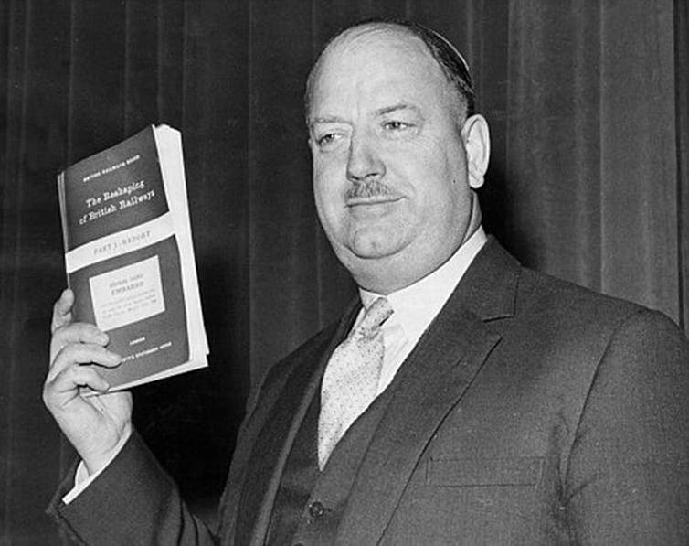
Dr Richard Beeching | 1964
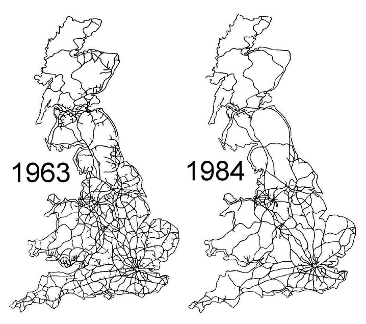
The Beeching Cuts | mapped
Norfolk Heritage Explorer
The Norfolk Heritage Explorer records what’s left of the Norfolk and Suffolk Joint Railway in great detail and much better than we could.
You can view their Monument type record, number 13585 here.